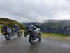
Last Sunday I rode from Bergen to Kristiansand, one of Norway’s southernmost cities. A straight-forward trip down there along the coast, a route I’ve travelled too many times to count. . Two ferries and no less than three under-sea tunnels along that route. About 7 hrs riding time. Not much to report. Going back north on Tuesday though, I chose a scenic route looping counter-clockwise through the mountains and back to Ålgård and then the coastal route north to Bergen
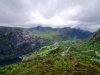
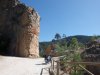
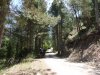
The scenic route consists of two parts, really, first the Suleskard mountain pass, known for its twisty and narrow roadway with every curve more blind than the previous one. Expect to find sheep in the roadway just about anywhere but mostly where you don’t expect them. The mountain pass tops out at appr. 1100 meters which is kind of a deal here; the highest-altitude highway we have is at appr. 1400 (and the highest accessible road is at 1860). Unfortunately it started to rain so not much of a deal this time except the remnants of snow drifts in places. And anyway these are the roads we have around here, so …
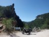
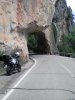
Lysebotn is a tiny place at the end of a deep fjord, existing on account of hydro-electric power generated in the area. Which is something we have at the inner end of every other fjord, really. The gimmick though is the road to get down there. First, a mountain pass topping out around 950 meters, this Tuesday around mid-day in a total cloud cover as the ceiling was at appr. 700 meters. Exciting and challenging to traverse in those conditions, visual range down to only thirty feet in places. When the German motor-homes come the other way occupying most of the roadway at that range, and their headlights are visible at maybe forty feet, one needs to be alert …
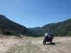
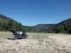
The descent takes you through twenty-six hairpin turns. Great excercise in clutch control, dipping-and-turning, and «head-and-eyes». There’s a full 180º turn in a 1200 meter (three quarters of a mile) tunnel that drops more than 100 meters (330 feet) over the course of its length. That’s pretty darn steep. The only other motorcycle I encountered in there was – a Super Ténéré, of course.
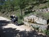
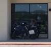
Coming back up to the start of the descent there’s a famous café known as «The Eagle's Nest» up top. They do of course have dedicated and FREE motorcycle parking, all the way forward, at the very edge of the mountain. As I got there, the only other motorcycle parked there was … a Super Ténéré, of course, UK registered. (Oh there was a Honda, but…). Didn’t see the rider anywhere, maybe he was hiking for a bit up the mountain side. It is a popular activity and the views are stunning, to say the least.
Total riding time from Kristiansand to Bergen was 12 hrs 30 mins which set a new record for me on the Super Ténéré (otherwise 14 hrs Bergen-Brekstad on an XJ 900 F in 2004). I’ll see what I can do about that next time I get a chance to «get out of town».
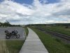
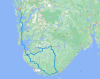
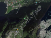
Route travelled -- top to bottom then counter-clockwise and back north
View attachment 92229
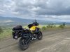
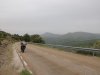
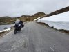
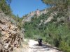
Suleskard mountain pass
View attachment 92230
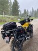
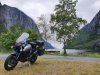
Lysebotn. The mountain range on the left is at appr. 700 meters (2100 ft)
View attachment 92231
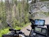
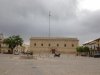
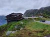
«The Eagle's Nest», take note of the premium parking spots for motorcycles (and other two-wheeled motorized vehicles)
View attachment 92232
Evel Knievel should take a look at this...
View attachment 92233
That's a drop of almost 700 meters (2100 ft). The hairpins in the picture are the easy ones...
View attachment 92234
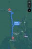
The hairpins and the tunnel. «The Eagle's Nest» is at the orange marker.
View attachment 92235