Cell phone and tablets for navigation

Checkswrecks

Ungenear to broked stuff
Staff member
Global Moderator
2011 Site Supporter
Joined
Mar 7, 2011
Messages
11,553
Location
Damascus, MD
Re: Android Navigation Apps

I have a Samsung S5 on the handlebar and the Garmin Montana above the speedo. One thing which has been great for both is that I wrapped and hot-glued velcro loop material around a stylus and have a couple of pieces of velcro loop material on the bike that it can stick to. Even if the gloves have the conductive tips, I have no more problems with fat fingers on little screens.
 

ScottMc

New Member
Joined
Dec 9, 2014
Messages
11
Location
Poulsbo, WA
Re: Android Navigation Apps

I just did an Alaska trip with my Samsung Galaxy Note 4 in a Ram 'X' mount. I downloaded Osmand and Co-Pilot. I found that I preferred Co-Pilot. The map downloads are huge but I put them on an equally large SD card so it wasn't a problem . I liked the screen size of the Note 4 for this application and figured out that I could take pictures through a bug encrusted windscreen with it. ::012::
 

lastparrot

Member
Joined
Mar 29, 2015
Messages
89
Location
Tuscaloosa, Al
Re: Android Navigation Apps

On my recent trip to the beach I used Copilot to navigate my route. I liked the fact that it had a motorcycle vehicle type that avoided the interstate unless needed. You get at most 3 alternate routes and can drag and modify your selected route to perfect it. Downloadable maps, unintrusive notifications and visual cues are nice.
 

Checkswrecks

Ungenear to broked stuff
Staff member
Global Moderator
2011 Site Supporter
Joined
Mar 7, 2011
Messages
11,553
Location
Damascus, MD
Re: Android Navigation Apps

File this under First World Problems:


I was using the Samsung S5 to navigate to a restaurant where I was meeting my son last night. It was rush hour and traffic was really heavy, so no time to play with the phone once the destination was in it and active. He kept trying to text me with updates about where he was, time he would get there, etc. Every time, the text app would lock up the nav app. There was only time enough to hit the X to close the text, but in 2 minutes I'd get a reminder pop-up.


Argghh.
::)


I keep forgetting to turn the notifications off when I use it to navigate.
 

Checkswrecks

Ungenear to broked stuff
Staff member
Global Moderator
2011 Site Supporter
Joined
Mar 7, 2011
Messages
11,553
Location
Damascus, MD
We've had a number of threads about GPS that have wandered off to have some content about using a cell phone instead of a GPS, so thought it time to have a thread just about using cell phones.

I'd been running the phone parallel to a Garmin Montana for the last couple of years, largely just as a music player, but also for nav when in the city. When the Montana fell from the Garmin Rugged Mount and got lost, I couldn't justify spending another $400+ and simply moved the phone up to where the Montana had been. Haven't looked back.

The usual discussion points in using cell phones are:

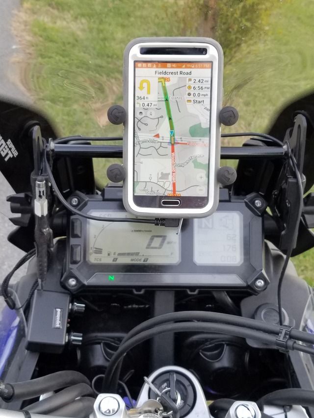
1. Built in GPS that can run stand-alone. Most now are like this Samsung Galaxy S5 (Android) and have it.


2. Software. Some of the early stuff was pretty bad, so fortunately that's a past issue. I'm running Osmand+ ($6.49 in Playstore) which can be set up very similar to a Garmin display, plus it has other types of possible displays. In this thread, I'd like to see examples of what others are running.

3. Cell reception versus needing to load offline maps. It's very easy to load big chunks of the country now, especially on phones which can take a micro-SD chip. With Osmand+ you choose what to load of the individual States, topo, and POI. This way you won't max out the memory in phones which don't have micro-SD card slots.

4. Want it waterproof. A number of phones are at least water resistant now.

5. Charging. Still a draw-back, as the plugs can short in the rain. But then, a charged phone can run for hours when the cell, wifi, and Bluetooth are turned off. I have a USB outlet that plugs into a SAE connector. The SAE connector can also be used for the winter Battery tender or to run an air pump.


6. Screen visibility. Some phones are nearly impossible to see in sunlight. This one is pretty good when in the high contrast display mode. My biggest issue is seeing through the screen protector of the Otterbox, so may ditch it.

7. Mounting. Lots of options. I've had zero problems with the RAM Cross Mount, but do use an elastic strap back-up which goes over the 4 corners. (Found the elastic on Amazon)


So what else do folks have and like?
 

Jimboni

New Member
Joined
Mar 31, 2016
Messages
2
Location
Rockies
Your points above are well taken, and for many riders I think this is a fine solution. I use this approach when I know I will have good GPS / cell signal and am at least a little bit familiar with the roads and destination.
If you are just navigating from A to B, and you can give up some of your mp3 space for local maps, a phone will work very well. However, there are some cons, and these become more evident on longer tours where I cover many states per day:

1. Numerous custom waypoints and on the fly re-route / detours are impossible or too fiddly to manage on a phone and operate safely on the bike.
2. Screen manipulation requires two ungloved fingers to perform (or conductive gloves) for most phones.
3. Music storage and offline maps - you can't have them both, or have to accept a limit.
4. Overheating - running concurrent tasks like navigation, phone (scanning for cell towers), playing music, etc., over several hours can get the phone very hot! I'd rather spend $400 on a gps than $600-700 for a new phone.

I ended up having to use both devices for any long rides: a hard wired zumo 665 with all US campsite POIs and dealers, all my custom waypoints previously identified and downloaded to the device. My phone runs Real Time GPS Tracker, so my family knows where I am, and plays music. The phone is paired with the GPS so I can easily see when I get a call (better be important!). I use a mixit to combine phone with GPS audio. Bluetooth music quality is unacceptable, IMHO, and the Garmin mp3 player is the worst I have heard since transistor radio days. Plus, I like to wear ear buds for hearing protection anyway. Admittedly low tech, but this works very well and does not overburden the devices or the charging system.

If you have the space and charging overhead, you could also run a phone with offline maps and use an ipod or second phone for the music side of things.
 

Bryce

Ya, Whatever!
Joined
Apr 14, 2015
Messages
429
Location
Acworth, GA
I use my old S4 Active for a gps and music on my bike. 64GB card added gives me plenty of room for maps and lots of downloaded Amazon prime music. Never had an issue with over heating.


I'll let ya know how it goes on my 10 day trip to Texas and New Mexico that I start on Friday
 

Checkswrecks

Ungenear to broked stuff
Staff member
Global Moderator
2011 Site Supporter
Joined
Mar 7, 2011
Messages
11,553
Location
Damascus, MD
Jimboni said:
Your points above are well taken, and for many riders I think this is a fine solution. I use this approach when I know I will have good GPS / cell signal and am at least a little bit familiar with the roads and destination.
If you are just navigating from A to B, and you can give up some of your mp3 space for local maps, a phone will work very well. However, there are some cons, and these become more evident on longer tours where I cover many states per day:

1. Numerous custom waypoints and on the fly re-route / detours are impossible or too fiddly to manage on a phone and operate safely on the bike.
2. Screen manipulation requires two ungloved fingers to perform (or conductive gloves) for most phones.
3. Music storage and offline maps - you can't have them both, or have to accept a limit.
4. Overheating - running concurrent tasks like navigation, phone (scanning for cell towers), playing music, etc., over several hours can get the phone very hot! I'd rather spend $400 on a gps than $600-700 for a new phone.

I ended up having to use both devices for any long rides: a hard wired zumo 665 with all US campsite POIs and dealers, all my custom waypoints previously identified and downloaded to the device. My phone runs Real Time GPS Tracker, so my family knows where I am, and plays music. The phone is paired with the GPS so I can easily see when I get a call (better be important!). I use a mixit to combine phone with GPS audio. Bluetooth music quality is unacceptable, IMHO, and the Garmin mp3 player is the worst I have heard since transistor radio days. Plus, I like to wear ear buds for hearing protection anyway. Admittedly low tech, but this works very well and does not overburden the devices or the charging system.

If you have the space and charging overhead, you could also run a phone with offline maps and use an ipod or second phone for the music side of things.

Hi Jimboni -


I've had no problem in doing re-routes with OSMand+ so am not sure what difficulty you've had. What software app were you using?


If you look at the lower right corner of the screen in the photo, there are "buttons" to zoom in and out, just like on a regular GPS. Zoom out, slide the map, and zoom in takes one finger.


On a tangent that's related, I find gloved finger tips are too fat for any of the GPS or phone screens. I have a stylus velcroed next to the phone mount and it sure makes accuracy less frustrating if on the slab where I have time to use it.


Why can't you have both music and maps? Like Bryce, I have a 64 Gig microSD and have run both all the time for years. btw - The SIM card has been removed and the phone is running offline maps without cell service in stand-alone usage.


My son and I've been running multiple open apps on the Samsung S4 and S5 since each was introduced. I've had and seen iPhones with heat issues (we carry the 5S for work), but never heard of it with these.


Cost was a big part of this, as I already had the spare phone. If I didn't you can buy brand new Android phones at Walmart and BestBuy for less than $25 if you watch for sales.


My biggest two concerns are ruggedness and the electric port at the bottom of the phone. The Galaxy S5 is in a big rubber OtterBox which seems to have damped the vibes and hammering for the years I've been doing this. But then I killed a couple of Montanas and am positive the Montana was locked in the rugged mount on the morning I lost it, so guess that each kind of device isn't immune to some kind of problem.


My biggest complaint with the OSMand+ is how many potential things there are to choose from for setting it up. If I want to change something about the display, it can take a little bit to find the option in the menus.
 

Checkswrecks

Ungenear to broked stuff
Staff member
Global Moderator
2011 Site Supporter
Joined
Mar 7, 2011
Messages
11,553
Location
Damascus, MD
Bryce said:
I use my old S4 Active for a gps and music on my bike. 64GB card added gives me plenty of room for maps and lots of downloaded Amazon prime music. Never had an issue with over heating.


I'll let ya know how it goes on my 10 day trip to Texas and New Mexico that I start on Friday

Which app do you run for the maps?
 

Chuck B

New Member
Joined
Apr 2, 2014
Messages
301
Location
Flagstaff AZ
I've been running Nokia's HERE Maps for Life for software and has been working well. What I have found disappointing is mounts to hold my Nexus4 I've dedicated on my bikes. I've tried a 1/2 doz different holders but didn't trust any of them when offroad. I recently ordered one from www.Rever.co and found it far better. I'd also suggest looking at what Rever offers for software. They are tied to Butler Maps and while I haven't made any trips using their software it seems to be very motorcycle oriented and specifically designed for tablet and cell phone users.
 

Bryce

Ya, Whatever!
Joined
Apr 14, 2015
Messages
429
Location
Acworth, GA
Checkswrecks said:
Which app do you run for the maps?
Osmand+ for when I'm following tracks and routes.
Co-Pilot for point to point stuff and around town because it's got traffic info.

the Open Street Maps poi databases and addresses are lacking, but getting better... that's my biggest complaint.

I'm not really a fan of Locus, but have it installed.
 

cmoresky

2015non-ES get out, cmoresky
Joined
Feb 22, 2016
Messages
37
Location
USA
Hyea,

I've been using my iphone 5 for routing for most of my trips the last few years. In city or quick navigation I ask Seri to route to __destination if I know it using voice command over Sena10 and the stock apple map. It's not my favorite map but it will get me where I need to go for quick nav. I also have a stlyus on a tether for making screen adjustments or to clear that WIFI in range notification junk that can happen. USB charger in tank bag or from 12v socket keeps me in full charge.

Yes, I listen to music or audio books almost every commute and trip.

I have my phone mounted the Ram Xgrip to a bar clamp and I use a plastic bag and rubber band in light rain, put it away in the tank bag during downpours but still audio direction. I too suffer heat stroke in full sun so its not an Arizona or back country solution.

For rally ridding or distance work, I use a MotionX GPS-Drive edition with purchased voice navigation. I add in lat/lon waypoints before or addresses. I like to see the zoom out view most of time but it does turn by turn just fine as well. It has speed, ETA, dist as well as Waze style info about police or traffic and will do rerouting if I make a detour or pit stop. it will also do multiple waypoints in one trip but not show ETA to each, just the finish.
If i am pressed for time, I keep an evernote of the lat/lon list of bonus or waypoint handy and can import a destination copy/paste on the road as well as search for comercial/city destinations fairly easily but without gloves so not while riding. It can load offline maps but does it at 8x speed as if you were driving so it takes its sweet time doing a long trip.

I bought a waterproof case for the phone for this season but haven't tested it yet. I don't have a sun heat solution other than to shade it. I love being able to reach my audio content in all its forms including Audible, Pandora, playlists, etc.

I've learned to disable notifications so I get less pop ups and the stylus is very effective on such a stable bike. Used on my Vstrom last year, this was not the case and difficult to punch the stylus at the right button....

I do worry that its my only phone and if it gets damaged or lost I am both out of directions as well as out of contact so i tether it best I can as others have said. New case might reduce that concern.


Jeff/Cmoresky
in MA
 

88millimeter

Member
Joined
Jan 23, 2013
Messages
247
Location
Tx
I recently started using my Iphone for offroad routing. I use Gaia GPS. It works great, i can create routes in Google maps using streetview to choose the best roads and trails and then i email the KML or gpx file to myself and open with my phone. Gaia will allow you to download the maps for an area or you can choose to download only the map for your route, this saves a lot of space on your phone but you can't deviate too far from your original route.
 

Chuck B

New Member
Joined
Apr 2, 2014
Messages
301
Location
Flagstaff AZ
A little off topic...

Something I recently discovered on Amazon. If you pull down the Department tab on top left, select "electronics & Computers" then select "Trade in your Electronics" you'll see a list of categories. If you select say Phones they list items both to get trade in quote and for sale items. I saw a few S5's for under $60 and a few Nexus4's for under $40. Great way to get a phone that you don't have to sweat too much if lost/damaged.
 

Checkswrecks

Ungenear to broked stuff
Staff member
Global Moderator
2011 Site Supporter
Joined
Mar 7, 2011
Messages
11,553
Location
Damascus, MD
Two "don't do what I did items from using the Samsung Galaxy S5 the other day.


The RAM Cross mount is now permanent on the Tenere and I was going to use the phone on the KTM 690 so threw a bicycle case on the handlebars to hold the Otterbox case that the phone is in. The phone now had the Otterbox screen protector under the dirty clear vinyl of the bicycle case. Add in my visor and that's 3 layers of plastic, at least two of which were filthy. I could hardly see the screen - or so I thought.


Turns out that I had the screen brightness turned way down. duh. When turned to max the thing was fully legible.


Next issue was that I left the phone in the Otterbox, which was still in the bicycle case. The thing was sitting in the sun while we went in for lunch and the phone shut down due to heat. No surprise, just a reminder that almost any phone or tablet will do this. After taking the phone out of the Otterbox and letting it cool for only a couple of minutes it was ready to go again.
 

SilverBullet

Well-Known Member
Joined
Dec 30, 2014
Messages
1,178
Location
Harmaston, TX
Chuck B said:
A little off topic...

Something I recently discovered on Amazon. If you pull down the Department tab on top left, select "electronics & Computers" then select "Trade in your Electronics" you'll see a list of categories. If you select say Phones they list items both to get trade in quote and for sale items. I saw a few S5's for under $60 and a few Nexus4's for under $40. Great way to get a phone that you don't have to sweat too much if lost/damaged.
I don't see any for sale items, only trade in quotes. Is there something I'm missing?

I've been using OsmAnd now for over 6 months and very happy with it. I used it overseas in the Philippines and it performed flawlessly. Only recently did I max my 10 downloads and have upgraded to OsmAnd+ for $6.49 and now even happier. $6.49 sure beats $649 for a Montana and my old eyes can see the bigger S5 screen better. I've yet to have a gpx not load perfectly unlike the expensive Garmins which often have issues.

_
 

neilbarnwell

Member
Joined
May 15, 2015
Messages
58
Location
Worcester, UK
I use my main mobile phone (Samsung S5) in a cheap plastic/velcro "waterproof" bag on the handlebars. In terms of hardware, it's not impressive. The Tumbler came with the Touratech Garmin locking bracket fitted from the previous owner, but there's no way I'm buying the Garmin 690 when Google Maps navigation works so well (see below). I'd love to find a way to fit the phone into the Touratech bracket. I'm thinking of prototyping something in wood and maybe getting someone to 3D-print it for me, but that's the subject for another post.

Google Maps is simply fantastic, here are the cons and pros:

Cons:
  • While it's possible to download portions of the map to your phone, the actual navigation is still done online. I use a free app for those rare occasions when I've mislaid myself and have no signal.
  • It doesn't have the "windy roads" option that some motorbike-specific units do (TomTom Rider and Garmin 690 both have this feature).
  • You can't really operate it with gloves as it's a capacitive touch screen rather than a resistive one.
  • There are dedicated mounts/brackets for the most common dedicated GPS units, but other than the iPhone this isn't the case for phones yet.
  • Water resistance/charging options *could* be an issue but it's possible to achieve.

Pros:
  • Planning a route to a location is super easy on the phone - it's Google. You can use postcodes/zipcodes, street names, business names, or just drop a pushpin on the map.
  • You can plan a route in more detail on maps.google.com, adjusting the route by dragging it with your mouse to the specific roads you want to use, then you can send the result to your phone.
  • If you're online and in a country where it's available, you get detailed traffic information (and it'll even suggest automatically re-routing around problems).
  • As with some of the more expensive dedicated units, you get "HD" directions, which means it tells you which lane to be in at roundabouts/junctions etc, not just left/right.
  • Because it's Google, you get deep integration with other features on your phone:
    • Pressing the correct button on a Bluetooth headset (Scala Rider in my case) allows you to use voice activation to make calls, re-set navigation for an address in your phonebook, street address, etc, play music, set reminders and calendar entries, even send text messages (I'm not saying that's a good idea while riding your bike, but it beats taking your gloves off if you've pulled over and it's cold and wet.
    • If you have Google Now enabled, Google will watch for your upcoming appointments, and tell you when you need to leave to get there on time, taking traffic into consideration. This is useful if you're out on a ride and have to be home for a specific time, for example.
  • Updates are regular and free, for both maps and software features.

There's so many other good reasons to use Google Maps as well, these are just my favourites. Apart from the fact that it's visually much more polished than the competition, which is just aesthetics, really.
 

Use2btrix

New Member
Joined
Mar 28, 2016
Messages
103
Location
Texas
So I downloaded osmand+ and it's great for maps, but does it work for actual turn by turn navigation? I cannot seem to get it no matter what I try. Maybe it's just for use as maps?
 

Checkswrecks

Ungenear to broked stuff
Staff member
Global Moderator
2011 Site Supporter
Joined
Mar 7, 2011
Messages
11,553
Location
Damascus, MD
Use2btrix said:
So I downloaded osmand+ and it's great for maps, but does it work for actual turn by turn navigation? I cannot seem to get it no matter what I try. Maybe it's just for use as maps?

In my photo on the previous page you can see that I was using it for turn by turn nav. Dig through all the settings or look in their documentation and you'll find it.
 
Top