Abandoning all adult responsibilities, Sunday morning of Labor Day Weekend found spkldoe and me astraddle Alegany setting out to visit Briery Knob and Hills Creek Falls. We made our way up and over several ridges, stopping momentarily to commune with a very friendly saddleback sow, then onward to a pit stop at Droop Mountain State Park Headquarters.
We pointed Alegany up Briery Knob, a 4500’ summit on Black Mountain in the Monongahela National Forest near the Pocahontas/Greenbrier County line. The parent ridge divides drainages of the Cranberry and Cherry Rivers to the north and west from Hills Creek of the Greenbrier River to the east. Briery Knob Prominence was once the site of a lookout tower where dutiful sentinels once watched carefully over the land for signs of fire during the biannual seasons. The fire tower has been replaced by a solar-powered telecommunications weather monitoring facility. Outside the Mon, just to the south and west, is an extensive area of commercial forest. Timber and coal resources have been heavily extracted for many years, leaving a highly fragmented and degraded landscape though moonscape seems more apt. Industrial beasts have constructed and maintained a permanent inter-county dirt road system that calls to adventurous motorcyclists and ATV riders.
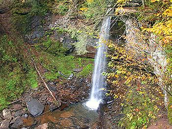
Hills Creek, a headwater of the Greenbrier River, is a designated scenic area. An elaborate trail leads into a deep canyon where visitors, immersed in temperate deciduous highland forest, marvel three waterfalls including WVs second highest. The current summer drought has reduced flows of highland streams to a trickle, a situation set to be remedied in the opposite extreme as Tropical Depression Lee prepares to dump heavy rain across the region. About half way down the trail, spkldoe’s fuel injection system began to act up (perhaps too much mocyclin’ and not enough trailin’?), so the middle falls appears in the video. Shown is a web rendering of the often photographed lower falls during typical late summer/early fall flow…
Followin’ our hike, we headed back up to Briery Knob Road via Bear Run to seek the south fork of Cherry River drainage. Three lefts, a right and 30 miles of forest road as the South Fork matured found us in Richwood, WV. We stopped for a long overdue visit with a lifelong friend before rolling south on WV 20 to the comforts of home.
Briery
briery
We pointed Alegany up Briery Knob, a 4500’ summit on Black Mountain in the Monongahela National Forest near the Pocahontas/Greenbrier County line. The parent ridge divides drainages of the Cranberry and Cherry Rivers to the north and west from Hills Creek of the Greenbrier River to the east. Briery Knob Prominence was once the site of a lookout tower where dutiful sentinels once watched carefully over the land for signs of fire during the biannual seasons. The fire tower has been replaced by a solar-powered telecommunications weather monitoring facility. Outside the Mon, just to the south and west, is an extensive area of commercial forest. Timber and coal resources have been heavily extracted for many years, leaving a highly fragmented and degraded landscape though moonscape seems more apt. Industrial beasts have constructed and maintained a permanent inter-county dirt road system that calls to adventurous motorcyclists and ATV riders.
Hills Creek, a headwater of the Greenbrier River, is a designated scenic area. An elaborate trail leads into a deep canyon where visitors, immersed in temperate deciduous highland forest, marvel three waterfalls including WVs second highest. The current summer drought has reduced flows of highland streams to a trickle, a situation set to be remedied in the opposite extreme as Tropical Depression Lee prepares to dump heavy rain across the region. About half way down the trail, spkldoe’s fuel injection system began to act up (perhaps too much mocyclin’ and not enough trailin’?), so the middle falls appears in the video. Shown is a web rendering of the often photographed lower falls during typical late summer/early fall flow…
Followin’ our hike, we headed back up to Briery Knob Road via Bear Run to seek the south fork of Cherry River drainage. Three lefts, a right and 30 miles of forest road as the South Fork matured found us in Richwood, WV. We stopped for a long overdue visit with a lifelong friend before rolling south on WV 20 to the comforts of home.
Briery
briery