Best time for Washington Oregon DS Trip

Best Time for Washington Oregon DS Assault

  • First Two Weeks of September

    Votes: 2 40.0%
  • Middle Two Weeks of September

    Votes: 2 40.0%
  • Last Two Weeks of September.

    Votes: 1 20.0%

  • Total voters
    5
  • Poll closed .

johnpitts01

Super Tenere Blue
Founding Member
Joined
Dec 13, 2010
Messages
324
Location
New Jersey
Alright you Pacific Northwesters!

Time to help a right coast crew planning an assault on the PNW in 2012.

What's best for this ride; first two weeks of September, middle of September or last two weeks.

Consider all factors; heat, cold, rain, snow, bugs, tourists, etc.?


A couple of easterners will have bikes transported to Seattle. We will fly in, collect the bikes and head west through Cascade National Park to connect with the Washington Back Country Discovery Route then head south on the route.

We will connect to the Oregon Back Country Route with some modifications. Then make our way to the Lost Coast of California.


All comments, thoughts and ideas are most welcome.


JB
 

markjenn

Active Member
Founding Member
Joined
Oct 22, 2010
Messages
2,427
Location
Bellingham, WA
Sounds like a fun trip.

Sept is an optimal time for a high-country trip in this neck of the woods. Unlike Oct, Sept is generally still a consistently dry month (although not as dry as Aug), the Aug heat inland will have started to break, and the crowds after Labor Day will have thinned. All the high-country will be snow free with virtually no risk of new snow.

As to what part of Sept, I don't think it matters a great deal. Your chances of rain and cooler weather do increase a bit later in the month, but as you get away from the coast, it will also be cooler. E. Wash and E. Oregon can be extremely hot in Aug and into Sept. Six-for-one, half-dozen for the other.

Another factor to consider is shorter days. If you like to ride late and camp late, the days are getting a few minutes shorter every day in Sept.

I'd probably schedule for the two weeks after labor day or perhaps a week later than this.

My only concern is that it sounds like you may be wildly ambitious in your plans. WABCDR, ORBCDR, and Lost Coast for a single dual-sport trip? I've done most of all three and what you're talking about is going to be absolutely grueling, especially if you're including overall transit time in these two weeks. These back-country routes really suit themselves to 150-mile days, not 300-mile days AND some downtime for the inevitable flats, mechanicals, navigation errors, hunting for gas/food/beer, unanticipated closed gates, etc. Not to mention that about half these trips seem to have occasional detours to get medical care. And even with new tires, your are probably going to have to spend a half day mid-trip to change tires.

Personally, I'd suggest you not do much hard-core planning on your mileage and stops. Just start out and see how it goes, setting your pace and schedule based on your mood - when you're at the end of your time, turn around and come home.

Are you planning on taking an S10? While folks do take big GS-type bikes, the optimal bikes are the 400 and 650 singles. I've always used my DRZ on these routes and while most of the routes can be done on a big bike, there are some areas where you either have to be an expert rider or you will have a fair number of drops. The routes do have areas of rocks that will totally beat the crap out of a big bike and test every aspect of your luggage security. If I were taking my S10, I'd have my Benchmark maps handy and not beat the bike through very tough sections, but instead find another route.

- Mark
 

johnpitts01

Super Tenere Blue
Founding Member
Joined
Dec 13, 2010
Messages
324
Location
New Jersey
Mark:

Thanks so much for the detailed response. I may come back to you with additional questions and help if it's ok with you.


We do a major well planned trip every year. 10-14 days 2000 to 3000 miles. We rely heavily on local intel to plan the timing for the best possible conditions. We use the same intel to plan a route that avoids anything too technical while allowing us to enjoy the best of the scenery and camping in the areas.

For example we will bypass the toughest parts of the OBDR, especially the slog through the desert. Same for the WBDR. We will ride some, probably most of it, but we will plot go arounds for anything difficult.

As for the bikes, we will likely be a mix of smaller and bigger bikes. One of our crew handles a GSA like it was a 650. Another on a KTM 950 Enduro is a former International Six Days Trials rider and Enduro champion that can handle the big KTM.

We have maybe the best resource in the USA for planning routes in the North West USA - Tony "Byways" Huegel. Tony has been instrumental in helping us put together epic rides in Idaho, Colorado, Utah, Montana, Nevada....

I'd urge anyone to contact Tony to help plan memorable routes in the area:
tonyhuegel@gmail.com

Ride Reports for our epic trips below. We are really looking forward to a trip in the PNW that rivals or surpasses these.

Idaho http://www.advrider.com/forums/showthread.php?t=166318
Forever West (an alternative to the CDR) http://www.advrider.com/forums/showthread.php?t=647968
Surf and Turf (New England) http://www.advrider.com/forums/showthread.php?t=530858
TAT East http://www.advrider.com/forums/showthread.php?t=272563
TAT West http://www.advrider.com/forums/showthread.php?t=410130


JB
 

markjenn

Active Member
Founding Member
Joined
Oct 22, 2010
Messages
2,427
Location
Bellingham, WA
You've already gone beyond my level of planning, so I could probably learn more from you than vice-versa.

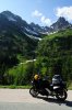
On routes, I like the idea of flexibility. While on both the WA and OR routes, I've sometimes found trying to exactly follow the plotted routes to be tedious and the road network in the woods is not static. Instead, I typically use the routes as suggested places to go and modify as I go along. The OBCDR is especially tough in places as it was developed 15 years ago and AFAIK, no one has consolidated all the experiences of folks since in one place; a good 10% of the route no longer exists. There are lots of places on the OBCDR where the plotted route takes off on a goat trail that peters out to nothing, but you can bail on very nice forest service roads and have a great time. For example, FR16 from Seneca to Unity is all paved and the OBCDR route snakes all around it, but only uses it for a few small sections. Personally, I find FR16 absolute bliss on a dual-sport bike so there is not much loss in just finding your own way.

While having a GPS is essential, having good paper maps is also very important as none of the GPS maps available today are very good in accurately showing how challenging a road is, or even showing it if is pavement or grave/dirt. You get into the woods, and the GPS road network spider webs into hundreds of roads with no differentiation of which is the thorough route you need to follow. In regards to paper maps, I don't think any maps touch the Benchmark series for adventure riding - I'd definitely have the WA, OR, and CA (if you get that far) mapbooks along. You can order the forest service maps (or borrow mine if you want), but they're way out of date, bulky, very hard to read, and have too much detail for x-country riding. The Delorme stuff pales in comparison to the Benchmarks.

http://www.benchmarkmaps.com/

My back of the envelope calculations say that if you do the WABCDR from the CND border to around Carson, then trek to Walla Walla, do the OBCDR to Burns, then trek to Happy Camp, then do a typical Lost Coast route, that you'd have about 2K miles under your wheels. Even at a very aggressive 200 miles/day, that would 10 days right there with no rest days, mechanical days, tire-changing/maintenance days, etc. and no allowance for the trek to the start nor the trek back to Seattle. You can freeway back, but that's brutal in one day and no fun in two. Personally, I'd take 3-5 and enjoy some of the great roads along the OR coastal range.

Another issue is camping - since the areas you're in are very remote, you really want to camp, but at the time of year you're traveling, it starts getting dark around 6:30PM. To avoid setting up tents and cooking in the dark, you really want to be shutting down before 5PM or so and unless you're doing hard-core backpacking food, you'll need an hour or so to trek into town and get supplies. Given an hour to tear down camp, your typical riding day becomes 9AM-4PM, and with stops, you'll only have six or so hours on the bike. 200 miles/day in six hours is a 33 mph average, very tough for much of the route where you'll average 25 or so.

Maybe you guys are hard-core, can fix flats in five-min, pound through rock gardens at 35 mph, and break camp in 10 minutes. If so, disregard the panderings of this 58-you adventure rider. But if you want to get full value out your time in WA and OR, I'd recommend you leave CA for another trip or at least consider it optional. It really deserves another trip. Or sorta punt on the whole BCDR deal and just work out a mostly good-through-road route on your own where you can head to CA more directly and stay on better roads and are closer to civilization.

- Mark
 

johnpitts01

Super Tenere Blue
Founding Member
Joined
Dec 13, 2010
Messages
324
Location
New Jersey
Mark:

Great info and intel. Exactly the kind of stuff we research as completely as we possibly can in planning our routes. THere's a good chance we will bypass huge sections of the OBDR. May come back to you for more as you seem to have lots of local knowledge. We finished up our TAT West ride in Oregon and loved it. We all promised to return to Oregon soon.

Age wise we range from 40's to late '50's.

We LOOOOOVVVVEEEEE fire roads. Prefer unpaved fire roads. We swear by the Benchmarks. We create a general route, then check and double check against the Benchmarks, Google Earth and local sources for intel.

FYI we will have the bikes trucked from NJ to Seattle to a bike shop or maybe Touratech. We will fly in to Seattle, collect the bikes, spend a day in final prep and head out the next morning. The current initial plan is to head east on Highway 20 through Cascade National Park and connect with the WBDR. We will skip Section 1 and part of Section 2 of WBDR. We will head south on the WBDR. If we learn of any technical sections we will route around. We llike riding off road, but we will not kill ourselves or risk injury or bike damage just to tackle a tough section. Just not worth it. Once into Oregon we will probably create our own route based on what we've learned about the OBDR. We'll head south and west through Oregon, headed towards the coast. We'll then do the Lost Coast. At some point we will turn east across California headed for our final destination - Reno. In Reno we will drop the bikes at the freight company for their return east. We will fl out of Reno 15-16 days after our arrival in Seattle.

If you check our ride reports on ADV you will see we've been very succesful with similar trip lengths and times. Bear in mind we route on roads that are not too technical so we can make pretty good time. If we fall behind we always have the option to eliminate a planned leg or ride asphalt for a while to recover time.

We have a great group that gets along well. We are completely flexible and ready to adjust to deal with anything that comes our way.

Thanks again for your input. I will come back to you for sure for some specific pointers, roads, route questions, etc.


JB
 

markjenn

Active Member
Founding Member
Joined
Oct 22, 2010
Messages
2,427
Location
Bellingham, WA
John, you know what you're doing. Sounds like a wonderful trip. Want to expand your group for all or part? I'd (and maybe one or two others) would love to come along. Might be able to help with logistics too. PM me and we can carry on via email.

- Mark
 

digitalmoto

Lack of sleep does strange things to my brain.
2011 Site Supporter
2012 Site Supporter
Joined
Apr 27, 2011
Messages
428
Location
Hillsboro, OR
Meh. Overall, I agree with Mark. The answer really depends upon the El Nino / La Nina cycles.
Mind your fuel when crossing Oregon. A lot of places have closed in recent years.
 

johnpitts01

Super Tenere Blue
Founding Member
Joined
Dec 13, 2010
Messages
324
Location
New Jersey
Mark:

PM sent


markjenn said:
John, you know what you're doing. Sounds like a wonderful trip. Want to expand your group for all or part? I'd (and maybe one or two others) would love to come along. Might be able to help with logistics too. PM me and we can carry on via email.

- Mark
 

gillesgc

New Member
Joined
Oct 27, 2011
Messages
10
Location
Seattle
We LOOOOOVVVVEEEEE fire roads. Prefer unpaved fire roads. We swear by the Benchmarks. We create a general route, then check and double check against the Benchmarks, Google Earth and local sources for intel.

FYI we will have the bikes trucked from NJ to Seattle to a bike shop or maybe Touratech. We will fly in to Seattle, collect the bikes, spend a day in final prep and head out the next morning. The current initial plan is to head east on Highway 20 through Cascade National Park and connect with the WBDR. We will skip Section 1 and part of Section 2 of WBDR. We will head south on the WBDR. If we learn of any technical sections we will route around. We llike riding off road, but we will not kill ourselves or risk injury or bike damage just to tackle a tough section. Just not worth it. Once into Oregon we will probably create our own route based on what we've learned about the OBDR. We'll head south and west through Oregon, headed towards the coast. We'll then do the Lost Coast. At some point we will turn east across California headed for our final destination - Reno. In Reno we will drop the bikes at the freight company for their return east. We will fl out of Reno 15-16 days after our arrival in Seattle.

If you check our ride reports on ADV you will see we've been very succesful with similar trip lengths and times. Bear in mind we route on roads that are not too technical so we can make pretty good time. If we fall behind we always have the option to eliminate a planned leg or ride asphalt for a while to recover time.

We have a great group that gets along well. We are completely flexible and ready to adjust to deal with anything that comes our way.

Thanks again for your input. I will come back to you for sure for some specific pointers, roads, route questions, etc.


JB
[/quote]


You might want to consider taking the Mountain Loop Highway from Granite Falls to Darrington for the start of your trip. It will take you through some of the best views of the Cascades and through an amazing ride that will get you to the Cascades Highway at Rockport. It would be a great shakedown as well for the rest of the trip. The ride would include a sample of everything to come, stunning views, canyon carving, long fast sweepers, forest roads.
 

johnpitts01

Super Tenere Blue
Founding Member
Joined
Dec 13, 2010
Messages
324
Location
New Jersey
Mountain Loop Highway

Grizzley:

Mountain Loop Highway sounds interesting.
Our current plan is to take Highway 5 north from Seattle to 530.
East on 530 to 20.
20 East to Concully / Carlton to connect with the WBDR.

That's a fair amount of miles right out of the box. How much time / distance would we add by doing the Mountain Highway Loop?

Any difficult sections on the Mountain Loop Highway?


John
 

markjenn

Active Member
Founding Member
Joined
Oct 22, 2010
Messages
2,427
Location
Bellingham, WA
Mountain Loop Highway is passable in a car so no difficult sections. Maybe I've caught it on bad days, but I've never been a big fan - surprising level of traffic, deep/dark woods, greasy/snotty in the wet sections. It follows rivers, so it seems to wash out every third-winter or so.

S. Skagit Hwy which parallels 20 on the other side of the river all the way more-or-less to Marblemount is a wonderful drive and misses the nasty section of 20 through Sedro-Wooley and just E of there. Paved.

One of my favorite local dual-sport rides is FR18/FR17 from just W of Darrington over the top of the mountain and down to connect to S. Skagit Hwy. It's good double-track, nothing too challenging, but not car-friendly like Mountain Loop. This could be combine with Mountain Loop. But you may want to keep your eye on the ball and not start messing around early in the trip and instead get over to connect to the WABCDR.

- Mark
 

johnpitts01

Super Tenere Blue
Founding Member
Joined
Dec 13, 2010
Messages
324
Location
New Jersey
Seattle to WBDR

Mark:

Thanks for the advice.
Kinda what we're thinking - get from Seattle to the WBDR as direct as possible.

Looks like 20 through Cascade National Park has some pretty spectacular scenery on a paved road, yes?
 

johnpitts01

Super Tenere Blue
Founding Member
Joined
Dec 13, 2010
Messages
324
Location
New Jersey
Sedro -Wooley avoid

Mark:

Our current route has us heading North on 5, then east on 530 to avoid Sedro-Wooley.
530 to 20 in Rockport.

This is good, yes?
 

markjenn

Active Member
Founding Member
Joined
Oct 22, 2010
Messages
2,427
Location
Bellingham, WA
Re: Sedro -Wooley avoid

johnpitts01 said:
Our current route has us heading North on 5, then east on 530 to avoid Sedro-Wooley.
530 to 20 in Rockport.
The run through Darrington is nothing exceptional, but a nice ride. 20 is very scenic and has some great twisty sections around Diablo lake but always has a fair amount of traffic and is heavily patrolled.

- Mark
 

gillesgc

New Member
Joined
Oct 27, 2011
Messages
10
Location
Seattle
If your intent is to get to Conconully the first day, then skip what I said! I find 530 to be a nice ride, through farm country, and if you catch a clear day, the views in Darrington of the glacier are great. From Darrington to Rockport is flat, along the river, with great pavement, nice long curves for high speed runs. The North Cascades Highway is a beautiful run, taking you up into the Alpine then dropping you down into the Methow Valley. Over 30% of the Highway was chip sealed last summer. Check the highway conditions as they may be doing more of it next year. Many of the roads in the Okanogan area were being redone last year.

Traffic on the Cascades, 530 and other roads varies greatly depending on the days you go, obviously weekends being heaviest. If you start midweek, you get the best rides out here, but you fight some traffic from Seattle up I5. Remember that most of the Forest Service roads in the western areas take you through open range. I worked out there for several years and there are always cows grazing through the roads and had to slam on the brakes in the truck many times. Also watch out for cow patties, very slippery! Head the warning signs about the deer! Mule deer make a eastern whitetail look like toys. Almost hit bears twice last year, had one run across the road and missed by 5 yards while doing 70mph, the other blocked the Forest Road for a few minutes. Talk about pucker factor!

You can't go "wrong" out here. Have a great time!
 

Attachments

Top