Mid-Atlantic Back Discovery Route GPS - Tracks ready to download

Checkswrecks

Ungenear to broked stuff
Staff member
Global Moderator
2011 Site Supporter
Joined
Mar 7, 2011
Messages
11,521
Location
Damascus, MD
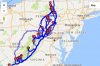
I'm itching to ride and the Mid-Atlantic Back Discovery Route was released on the first for anybody who wants to download the GPS tracks. It is mostly gravel or dirt roads (National Forest) and looks perfect for a few days on the Super Tenere when things warm up.
http://ridebdr.com/MABDR

The summary:

MABDR is a scenic ride for dual-sport and adventure motorcycles that uses dirt, gravel and paved roads to wind through remote parts of Virginia, West Virginia, Maryland, and Pennsylvania. Starting in Damascus Virginia, and ending in Lawrenceville, Tioga County, PA, this 1,080-mile route, primarily uses forest roads and rural country lanes, to lead riders through the Appalachian mountains, majestic forests, bucolic farming landscapes, Amish country, and locations that played pivotal roles in early American history.
 

twodogs

Member
2012 Site Supporter
2013 Site Supporter
2014 Site Supporter
Joined
Feb 21, 2012
Messages
262
Location
Chillicothe, OH
Thanks for the reminder...... ::008::

Now to get it to load..... can be fun at times.
 

SilverBullet

Well-Known Member
Joined
Dec 30, 2014
Messages
1,175
Location
Harmaston, TX
Looks like a good addition to Romney. Anyone know why the route does a 360° complete loop around Hagerstown? One leg is an easy out option?

_

Sent from my SM-G860P using Tapatalk
 

RCinNC

Well-Known Member
Joined
Aug 30, 2014
Messages
2,874
Location
North Carolina
This thing looks epic, and it goes right through the area in PA where I used to live. It'll make a terrific ride this summer, and it's apparently suitable for two up riding.

I downloaded the .gpx files, but right now I have to figure out how to get it to open in Tyre so I can look at the routes up close. Anybody have any suggestions? It's supposed to be a .gpx file, and Tyre can open those with no problem (along with a bunch of other type files), but when I try to open the MABDR file in Tyre, I get the warning that the file type isn't supported. I've never had any issues in the past downloading a .gpx file and opening it. My computer doesn't even identify it as a .gpx file: it just says it's a "file".
 

SilverBullet

Well-Known Member
Joined
Dec 30, 2014
Messages
1,175
Location
Harmaston, TX
My cell phone running Osmand+ opened it just fine. Try downloading it again, maybe an incomplete or corrupt download?
 

bigbob

Well-Known Member
2014 Site Supporter
Joined
Sep 9, 2014
Messages
1,671
Location
Des Moines, IA
RCinNC said:
My computer doesn't even identify it as a .gpx file: it just says it's a "file".
Try renaming it specifically adding the .gpx suffix.
 

RCinNC

Well-Known Member
Joined
Aug 30, 2014
Messages
2,874
Location
North Carolina
I thought that might be the case too, SilverBullet, so I downloaded it again and had the same issue.

I'll try opening it on OsmAnd.
 

RCinNC

Well-Known Member
Joined
Aug 30, 2014
Messages
2,874
Location
North Carolina
BigBob, thanks for that suggestion, that got it to open. Tyre has a maximum of 1000 waypoints per file, though, so I'm going to have to figure a way to work around that in order to get the whole route to display (or either try and cut the route into sections). Thank you for the help.

Well, it appears I'm stuck. I can open the file, but since the maximum file size for waypoints is 1000, I can only see the route about as far as Blacksburg, VA. Since I can't see the complete list of waypoints all at once, I can't edit the file into 1000 waypoint sections. I'll have to work on it to figure something out.
 

terrysig

Member
2012 Site Supporter
Joined
Jan 11, 2012
Messages
775
Location
Pittsburgh PA
Someone on ADVRider converted the gpx to 499 points for use on GPS that can't handle a lot of points. Goggle "advrider mabdr". The file is towards the end of the thread.
 

RCinNC

Well-Known Member
Joined
Aug 30, 2014
Messages
2,874
Location
North Carolina
Thanks Terry. I found the link and downloaded that member's .gpx file. However, when I opened it on Tyre, it looks like the photo I attached.

I ordered the Butler map tonight. I'll probably use that to prepare a simplified .gpx file.
 

Attachments

Checkswrecks

Ungenear to broked stuff
Staff member
Global Moderator
2011 Site Supporter
Joined
Mar 7, 2011
Messages
11,521
Location
Damascus, MD
SilverBullet said:
Looks like a good addition to Romney. Anyone know why the route does a 360° complete loop around Hagerstown? One leg is an easy out option?

_

Sent from my SM-G860P using Tapatalk

What is posted are tracks, rather than routes. These are where the mapper actually went and when you zoom in you can see a number of places he/they went to parking areas and other "real life" tracks.


I've ridden most of both the north and south legs of that loop and can't say from memory that either was much harder or different than the other.
 

gunner

Well-Known Member
Founding Member
Joined
Oct 10, 2010
Messages
419
Location
Lucas, TX
Here's a good tool to view the route, go to:

http://www.gpsvisualizer.com/

Upload the file and select the output format. I use Google maps. You can save the output file on your computer.

This website is also useful if you create a route in Google maps or Google Earth and need to convert it to a .gpx file.

When I downloaded the route file from http://ridebdr.com/MABDR, it did not have a .gpx file extension so I renamed it with the .gpx file extension and it worked fine.
 

RCinNC

Well-Known Member
Joined
Aug 30, 2014
Messages
2,874
Location
North Carolina
Every time I try and view the route based on the MABDR .gpx file, all I can see is the section from Damascus, VA to Newport, VA. I just tried it using gpsvisualizer, and converting the file to a Google Maps file, and the same thing happens. I'm sure it has something to do with the 6000 plus waypoints the the file is comprised of; I know Tyre can't handle that many, but evidently Google Maps can't either. I don't know what method you guys are using to see the entire route, but my methods sure aren't working.
 

terrysig

Member
2012 Site Supporter
Joined
Jan 11, 2012
Messages
775
Location
Pittsburgh PA
The mabdr is split up into 6 sections (i think 6 not in front of me). When i download the file i get each section but it definitely shows up on my montana as separate tracks. You may just be seeing the first section.

In basecamp and expertgps the entire route is shown at once.

I have not had a chance to play around with it yet but it looks good as downloaded.
 

SilverBullet

Well-Known Member
Joined
Dec 30, 2014
Messages
1,175
Location
Harmaston, TX
RCinNC said:
...I'll try opening it on OsmAnd.
Did you try this? If you did and still have issues then I'm dumbfounded.

I used the above link to open BDR website on my 3-1/2 yr old Galaxy 5. Downloaded "gps files" direct to my phone. File name downloaded as "MABDR Jan-2018.gpx" Moved it to my OsmAnd+ track folder and file opens in entirety showing complete tracks from Damascus to Lawrenceville.

Sent from my SM-G860P using Tapatalk
 

RCinNC

Well-Known Member
Joined
Aug 30, 2014
Messages
2,874
Location
North Carolina
Terry: I opened it in Basecamp, and get the same results: a section from Damascus VA to Newport VA. This was after I downloaded the file from the site, and added the .gpx file extension to the file. I've downloaded the file from the site twice, and have had the same result. I've never tried to input the device onto my Nuvi, since that wouldn't help me to easily review the entire route. I've never had an issue trying to view a downloaded .gpx file in Tyre.

Silver Bullet: I was able to open the file in OsmAnd, but still didn't see the entire route, just that segment I mentioned in the above paragraph.
 

SilverBullet

Well-Known Member
Joined
Dec 30, 2014
Messages
1,175
Location
Harmaston, TX
RCinNC said:
Silver Bullet: I was able to open the file in OsmAnd, but still didn't see the entire route, just that segment I mentioned in the above paragraph.
PM me your email address and I'll email you the file I downloaded. I also opened it in Base Camp and it's all there.

_
 

terrysig

Member
2012 Site Supporter
Joined
Jan 11, 2012
Messages
775
Location
Pittsburgh PA
Again I've not had a chance to play around with it but I might download another BDR just to see if it is split into sections.

I didn't hear anyone of advrider mention it was split into sections so that was a surprise but it makes sense. But possibly how my Montana interprets the MABDR file.

I'd also consider that they may have put up several versions to the BDR site since so many folks on advrider complained about the initial file not working. It's possible that they broke it up because of the data point limits on many GPSr.

I'll probably go back and download again to see if it's the same.

I prefer it to be all one track on my Montana so will go in and combine them if it remains separate tracks. A good chance to personalize also with various waypoints I already have in the PA sections.
 

Checkswrecks

Ungenear to broked stuff
Staff member
Global Moderator
2011 Site Supporter
Joined
Mar 7, 2011
Messages
11,521
Location
Damascus, MD
I don't have a Montana any more but know that when I did, it couldn't handle more than a fairly small file size AND couldn't handle more than a certain number of points. Beyond that, it would decide to truncate. Beyond just dealing with the aggravation of the Garmin user interface and Basecamp, it's one reason I went to Android with Osmand+.
 

RCinNC

Well-Known Member
Joined
Aug 30, 2014
Messages
2,874
Location
North Carolina
SilverBullet emailed me his file. It opened in Basecamp, but the route it generated in Tyre was insane. I'm not a big fan of Basecamp, so I've started to create a new file for Tyre based on the one SilverBullet sent me. I'm cutting out large numbers of the waypoints (which I seriously think is what's creating the issues in Tyre), and just using intermediate shaping points to keep the route on track. Once I'm done I'll make the file available to anyone here who uses Tyre for route planning.
 
Top